Brevoort Houses
Appearance
(Redirected from Breevort Houses)
Brevoort Houses | |
|---|---|
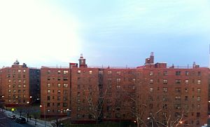
 Brevoort Houses in 2012 | |
 Location in New York City | |
| Coordinates: 40°40′46″N 73°55′21″W / 40.679330°N 73.922580°W | |
| Country | United States |
| State | New York |
| City | New York City |
| Borough | Brooklyn |
| Area | |
| • Total | 0.026 sq mi (0.07 km2) |
| Population | |
| • Total | 1,973 [1] |
| ZIP codes | 11233 |
| Area code(s) | 718, 347, 929, and 917 |
| Website | my |
Brevoort Houses, or Brevoort Projects, are a housing project located in the Bedford-Stuyvestant neighborhood in Brooklyn, New York. The complex is made up of 13 seven-story buildings with 896 apartments. The complex sits on 17.26-acres and construction was completed on August 31, 1955. It is owned and managed by New York City Housing Authority.[3]
The development is located between Bainbridge and Fulton Streets and Ralph and Patchen Avenues. The closest subway lines include the "C" at Ralph Avenue, as well as the "A" and "C" at Utica Avenue.
Notable residents
[edit]- Fabolous (born 1977), rapper[4]
- Steven Richardson, physicist[5]
See also
[edit]References
[edit]- ^ "Farragut Houses Population".[permanent dead link]
- ^ "Farragut Houses Area". Archived from the original on November 16, 2015. Retrieved November 23, 2015.
- ^ "Brevoort Houses". NYC.gov. Archived from the original on September 25, 2012. Retrieved March 23, 2012.
- ^ "The Fabolous Life". The Village Voice. Archived from the original on January 1, 2015. Retrieved March 23, 2012.
- ^ Crowe, Larry (14 July 2012). "Finding Aid to The HistoryMakers ® Video Oral History with Steven Richardson" (PDF). The History Makers. Retrieved 15 May 2023. https://www.thehistorymakers.org/sites/default/files/A2012_151_EAD.pdf
